
I contend that, with increasing frequency of rain storms in the Blue Mountains, there will be an increase in the number of rock falls and land slides. I just found a very interesting article that supports this contention, to the extent that it says that most such events happen after severe or extended rainfall. It also says that there is a rock fall of some sort somewhere in the Blue Mountains about once every month. The most likely place is on a talus slope, and many walking tracks cross such slopes or follow the base of the rock slide.
I have not found a paper that supports my contention that not only will there be an increase in rock falls, but that the larger types will become more common. An example is Carne Wall, which slipped away in a 200,000-cubic-metre rockfall overnight between August 1-2, 2025. If you go to the newly re-opened lookout at Pulpit Rock, you can see that enormous landslip and several others that have occurred since the rain storms that followed the 2019-2020 bushfires.
Here’s a graph of the heaviest rainfall days in the Blue Mountains. You can see that nearly all of them have occurred in the last few decades. 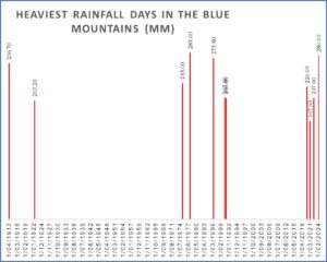
Here’s the article, that also maps the places rock slides are most likely to occur (though just drawing a red line around the cliff edges is not very helpful).